Cold blast brings heavy snow to the Northeast and deep freeze to the South
By Jason Hanna, Taylor Ward and Derrick Hinds, CNN
A powerful winter storm is bringing heavy and blustery snow to the Northeast and hammering the nation’s eastern third with strong winds, and will usher freezing temperatures, which could trouble crops in the South.
Roughly 42 million Americans across the eastern US are under some kind of winter weather alert.
About 4 to 8 inches of snow are forecast from the southern Appalachians to New England Saturday into early Sunday. However, areas of high elevation in the interior Northeast could see up to a foot of snow.
Eight inches or more already had fallen by late Saturday morning in parts of eastern Kentucky, southeastern Ohio, West Virginia, western Pennsylvania and upstate New York.
Especially intense snowfall — 1-2 inches per hour — are possible into early afternoon in parts of eastern Pennsylvania, northern New Jersey, eastern New York state, and western New England.
“New Yorkers should do their best to stay off the roads during this time,” New York Homeland Security and Emergency Services Commissioner Jackie Bray said Friday ahead of the storm.
In Pennsylvania’s Cumberland County, where there’s continuing snowfall, strong wind gusts and low visibility, at least 73 vehicles were involved in a crash and multiple people were injured by Saturday afternoon, State Trooper Megan Ammerman said on Twitter. “AVOID THE AREA,” Ammerman wrote.
Lines of thunderstorms hit elsewhere in the East Saturday, including Florida and the Carolinas. And the whole system has been accompanied and followed by strong, potentially damaging winds.
Florida Gov. Ron DeSantis declared a state of emergency in Clay, Highlands, Marion, and Putnam counties saying a cold front had brought “multiple severe weather hazards” across the northeastern and central part of the state, including heavy rain, thunderstorms, strong winds and isolated tornadoes resulting in damages and widespread power outages. The heavy rain also caused flash flooding of some bodies of water across northeast Florida, the governor said.
Winds already have interrupted electric service. By 9 p.m. ET Saturday, more than 85,000 homes and businesses were without power from the South to the Northeast — with the majority in Georgia, North Carolina and Pennsylvania, according to PowerOutage.us.
A few thunderstorms capable of damaging winds and an isolated tornado were possible Saturday afternoon over central Florida, according to the Storm Prediction Center.
The National Weather Service confirmed a waterspout came ashore on Fort Myers Beach on Saturday, resulting in a weak tornado. “People were panicking,” said Melissa Moore, who captured a video of the tornado, and people running on the beach as the winds picked up.
The weather service also confirmed an EF-1 tornado with maximum winds of 100 mph touched down in Ocala.
Ocala resident Hannah Laviolette posted a video on Twitter of tornado damage in her neighborhood Saturday afternoon. “My bed is next to my window and it started violently shaking so much so that I thought it was about to come flying off,” Laviolette said. She saw a funnel outside her window for a brief moment and when she later went outside, a neighbor said their bedroom had been “ripped open.”
Travel disruptions affected drivers and airline passengers alike. More than 1,300 flights within, into or out of the US had been canceled as of Saturday evening, according to the tracking website FlightAware.
Metropolitan areas along the coast, including Washington, DC, Philadelphia, New York and Boston are expected to collect rain and then some snow and sleet Saturday, though they will avoid the worst accumulations. Philadelphia may receive 2 to 4 inches of snow and sleet, with the other cities accumulating less, forecasters said.
Deep freeze coming to the South
A lobe of frigid air will sag deeply into the US following Saturday’s snow and rain, bringing freezing temperatures as far south as Florida.
March started out quite mild in the Eastern US and even downright warm in the Southeast. Many locations set record highs in the 70s and 80s as recently as last Sunday and Monday. The warmth has prompted many trees, flowers and crops to begin blooming already.
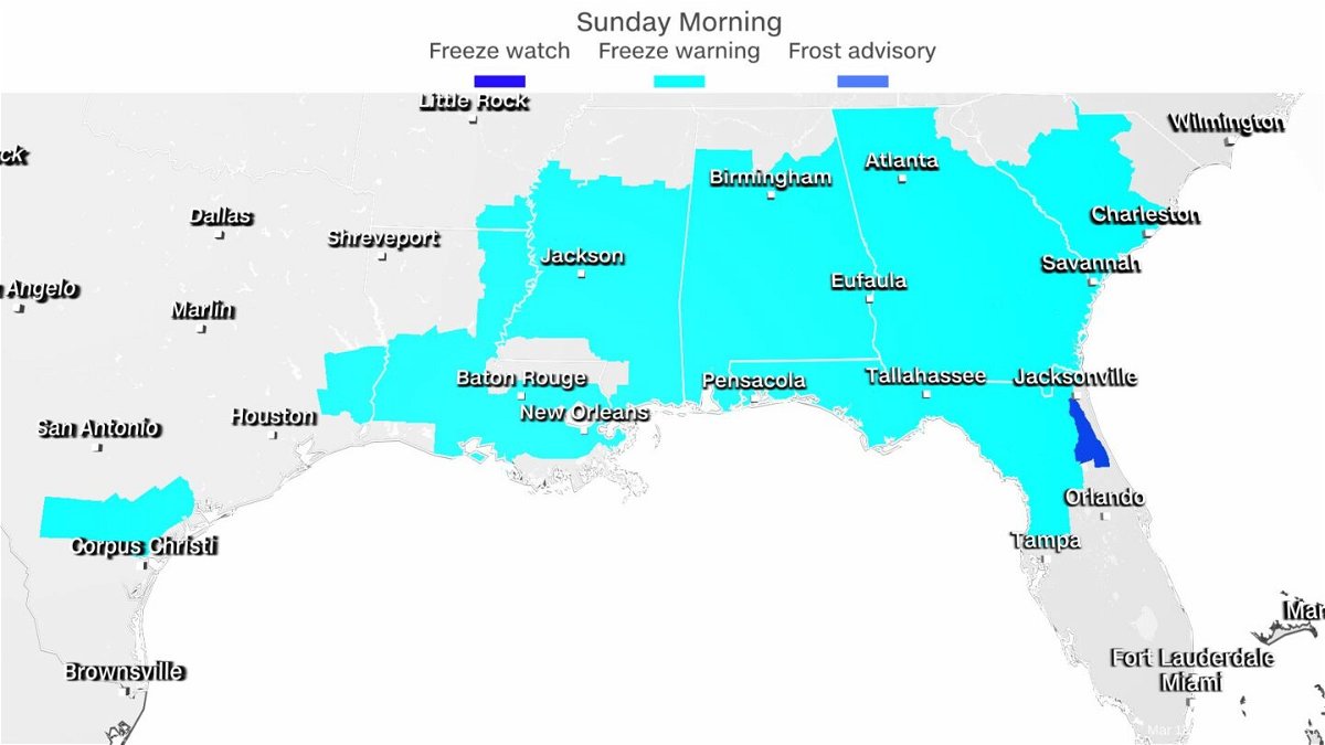
But Saturday’s storm system will bring plummeting temperatures and frigid air from Canada all the way down to the Gulf Coast. Locations from Louisiana to South Carolina and southward into Florida are expecting a deep freeze Saturday night into Sunday morning. Many of these locations will experience a hard freeze, with several hours below 28 degrees.
Low temperatures in the low to mid-20s and below freezing for a significant duration in much of the Deep South will threaten vulnerable vegetation already blooming there.
“Freeze conditions will kill crops, other sensitive vegetation and possibly damage unprotected outdoor plumbing,” the National Weather Service in Birmingham, Alabama, said.
More than 25 million people in the South are under freeze warnings Saturday night into Sunday. Cities under the watch include New Orleans; Jackson, Mississippi; Birmingham, Alabama; Atlanta; and Tallahassee and Jacksonville in Florida.
Temperatures will be in the teens for the Tennessee Valley into the Mid-Atlantic and Northeast, but freeze warnings are not issued for these locations because the growing season has not begun.
The-CNN-Wire
™ & © 2022 Cable News Network, Inc., a WarnerMedia Company. All rights reserved.
CNN’s Haley Brink, Melissa Alonso, Aya Elamroussi and Derek Van Dam contributed to this report.