Sprawling storm drops feet of snow, knocks out power with high winds and disrupts thousands of flights
By Meteorologists Mary Gilbert, Briana Waxman, and Chris Dolce, and Chris Boyette
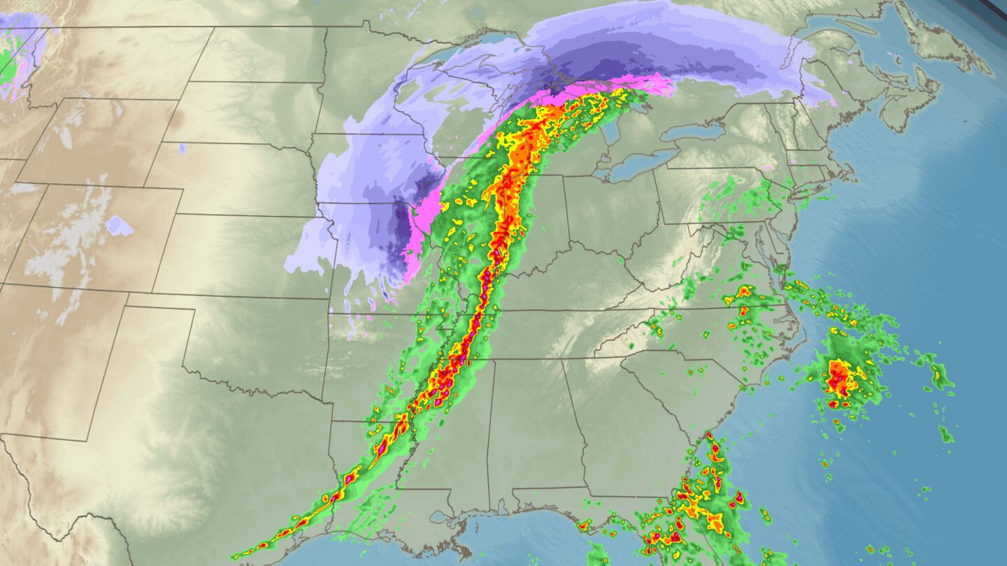
(CNN) — A sprawling, wind-driven multiday storm roared across the United States with severe thunderstorms to the south and blizzard conditions to the north, causing damage and disruptions along its path.
The system kicked up a powerful line of storms with winds up to 80 mph in spots that stretched from the Gulf Coast up to the Great Lakes on Sunday.
Monday, the line of storms rumbled along the East Coast, damaging structures, knocking out power to hundreds of thousands and causing thousands of flight cancellations and delays along the way.
The storm’s impacts:
- Severe storms with significant wind damage: There have been more than 800 reports of damaging wind gusts from Texas, Arkansas and Missouri to the East Coast since Sunday afternoon. There have been reports of minor injuries along with damaged or destroyed buildings in Arkansas and Tennessee.
- Heavy snow: Parts of the Upper Midwest and northern Great Lakes received 1 to 3 feet of snow from Sunday into Monday. Parts of the Great Lakes remain under blizzard warnings into Tuesday morning as strong winds and snow continue to create dangerous conditions.
- Flight cancellations: On Monday, more than 4,700 flights within, into or out of the US were canceled, and more than 11,800 flights were delayed, according to FlightAware.
- Power outages: At the peak of the storm, over half-a-million customers lost power as the intense line of storms moved through.
- Schools impacted: School districts in Washington, DC, and farther south announced closures, delays or early dismissals in anticipation of dangerous weather Monday. The largest school districts in Maryland and Virginia announced early dismissals, and school closures and delays were announced in Georgia, North Carolina, South Carolina, Minnesota, Wisconsin, Alabama and Florida, CNN affiliates reported.
Storms damage buildings, homes in the South and Midwest
Lawrence County, Tennessee, saw “significant wind damage in and around the Bonnertown community” overnight, Emergency Management Agency spokesperson Bill Phillips told CNN, adding there have been reports of minor injuries.
The National Weather Service later confirmed the damage was from an EF1 tornado, which reached 105 mph winds and spanned a little over 14 miles.
In Rector, Arkansas, the city maintenance shop and office building were demolished, Mayor Shawn Brandon told CNN. Most of a nearby home was also destroyed and a city park saw some damage. Tornado damage was also reported in Lexington, Alabama, which suffered damaged buildings and uprooted trees, the National Weather Service said.
Another EF1 tornado hit in Mt. Pleasant and Spring Hill, Tennessee, ripping the siding and roofs off structures with peak winds at 90 mph, the National Weather Service reported. There were no deaths reported in either tornado.
Storms flattened at least one structure and tore off roofs in central Kentucky’s Hardin County overnight Sunday. “Numerous properties were damaged in the storms last night, concentrated mostly in the Rineyville area,” but no deaths or injuries were reported, county Communications Officer Brian Walker told CNN in an email.
Buildings and properties in the county seat of Elizabethtown and other incorporated areas were damaged as well, Walker said. The National Weather Service is reviewing the damage to determine whether it was caused by straight-line winds or tornadoes.
On Sunday, the system produced at least one reported tornado near Humphrey in Arkansas County, Arkansas, according to the Storm Prediction Center. Hail up to the size of tennis balls pelted east Texas.
A cluster of tornadoes in central Illinois — four EF1s and two EF0s — uprooted trees, snapped power poles and ripped off some roofs as it passed through Sunday, according to the National Weather Service. Two EF1s and two EF0s also hit in southern Missouri, causing trees and structures to be impacted, including a donkey barn that was lifted off the ground, the agency said.
Historic snow, blizzard conditions
While the southern, warmer side of the storm generated severe thunderstorms, the cold, northern side was busy dumping a lot of snow.
Snow totals from the storm are between 1 and 3 feet so far from southern Minnesota into central Wisconsin and northern Michigan. They could climb a bit higher in some areas as blizzard conditions continue from eastern Wisconsin to the Upper Peninsula of Michigan overnight Monday into Tuesday.
Wausau, Wisconsin, picked up 23.4 inches on Sunday, making it the city’s snowiest day in about 130 years of records.
A snow emergency was in effect Monday for Milwaukee County, County Executive David Crowley announced on X. Non-essential departments are closed, including the courthouse and zoo.
After shutting down Interstate 80 both ways from around Iowa City to near Nebraska on Sunday, Iowa authorities reopened the highway Monday morning, but cautioned drivers that roadways may still be impacted by snow and ice.
In Wisconsin, many roads in northern counties were impassable Sunday, the state’s transportation department said, urging everyone in the region to avoid driving. And in Michigan, state police on Sunday said the Upper Peninsula’s Mackinac Bridge was closed and nearby roads across Cheboygan County were “impassable.”
Marquette, Michigan, is no stranger to high totals of lake-effect snow, but this storm was one of its biggest ever. The city received 34.5 inches of snow, breaking its largest two-day storm total on record of 31.9 inches from a March 1997 storm.
This story has been updated with additional information.
The-CNN-Wire
™ & © 2026 Cable News Network, Inc., a Warner Bros. Discovery Company. All rights reserved.
CNN Meteorologist Brandon Miller and CNN’s Taylor Romine contributed to this report.