
Weather Alerts

Flash Flood Warning for Ruidoso including the Salt and South Fork Burn Scar areas until 7:45 PM
The National Weather Service in El Paso and Santa Teresa has issued a Flash Flood Warning for Ruidoso including the Salt and South Fork Burn Scar areas until 7:45 PM this evening. According to doppler radar and rain gauges, heavy rain has fallen over the South Fork Burn Scar areas and up to 1.25 inches
Continue Reading Severe Thunderstorm Warning for Dona Ana and Otero Counties along US-70 including until 4:15 PM
The National Weather Service in El Paso and Santa Teresa has issued a Severe Thunderstorm Warning for Dona Ana and Otero Counties along US-70 until 4:15 PM. Main hazards are quarter-sized hail and 60 mile per hour winds!
Continue Reading Flood Advisory for El Paso and Otero Counties including Northeast El Paso and Chaparral until 11 PM
The National Weather Service in El Paso and Santa Teresa has issued a Flood Advisory for El Paso and Otero Counties including Northeast El Paso and Chaparral until 11 PM. Heavy rain from thunderstorms have caused minor flooding in the advisory area. Between a half of an inch and an inch has fallen and an
Continue Reading Flood Advisory for Hudspeth County until 8:45 PM
The National Weather Service has issued a Flood Advisory for Hudspeth County until 8:45 PM. Doppler radar indicated heavy rain due to thunderstorms. Minor flooding caused by excessive rainfall is expected, between half an inch to one inch has fallen.
Continue Reading Severe Thunderstorm Warning for West Central Hudspeth County including Tornillo until 6:15 PM
The National Weather Service in El Paso/Santa Teresa has issued a Severe Thunderstorm Warning for West Central Hudspeth County including Tornillo until 6:15 PM. The main hazard is 60 mile per hour winds and quarter-size hail. This storm is currently located 9 miles southeast of Indian Cliffs Ranch, moving southwest at 10 mph.
Continue Reading Severe Thunderstorm Warning for Central Dona Ana County including Las Cruces until 5PM, 60 mph winds and quarter-sized hail
The National Weather Service in El Paso/Santa Teresa has issued a Severe Thunderstorm Warning for Central Dona Ana County including Las Cruces until 5 PM. The main hazard is 60 mile per hour winds and quarter-size hail. This storm is currently located east of Dona Ana and Las Cruces moving west at 10 miles per
Continue Reading Flash Flood Warning for Northern Otero County including Mescalero until 6:45 PM
The National Weather Service in El Paso/Santa Teresa has issued a Flash Flood Warning Northern Otero County including Mescalero until 6:45 PM this evening. Doppler radar indicated a complex of thunderstorms producing heavy rain across the warned area. Between 1 and 1.5 inches of rain has fallen and additional rainfall up to 1.5 inches is
Continue Reading Severe Thunderstorm Warning for El Paso and Hudspeth Counties until 4:30 PM
The National Weather Service in El Paso/Santa Teresa has issued a Severe Thunderstorm Warning for El Paso and Hudspeth Counties. The main hazard is 60 mile per hour winds and quarter-size hail. This storm is currently located near Hueco Tanks, near US-180 and is not moving much.
Continue Reading Dust Storm Advisory for El Paso until 9 PM
The National Weather Service in El Paso and Santa Teresa has issued a Dust Storm Advisory for Dona Ana, El Paso, and Otero Counties until 9 PM. This includes West and Central El Paso. At approximately 8PM, an area of blowing dust was located over West El Paso with less than one mile of visibility
Continue Reading Dust Storm Warning for Las Cruces until 8:15 PM
The National Weather Service in El Paso and Santa Teresa has issued a Dust Storm Warning portions of southeastern Dona Ana County until 8:15 PM. The warned area includes Interstate 10 from Anthony to Las Cruces. Up to 40 mile per hour winds can cause near zero visibility.
Continue Reading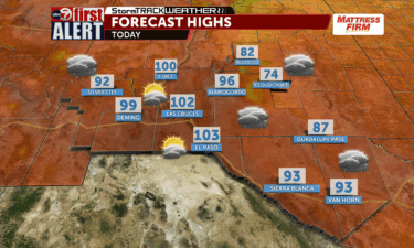
First Alert for thunderstorms and dust this weekend
EL PASO, Texas (KVIA) — This weekend we will see significant changes in the weather as widespread thunderstorms are expected. The storms will begin in the higher areas and move down into the lower deserts by evening. These storms could bring strong wind gusts with some reaching over 50 mph, along with blowing dust despite
Continue Reading
Dust Advisory for El Paso until 6:30 PM
A Dust Storm Advisory has been issued for El Paso until 6:30 PM. A dust plume was located over Northeast El Paso, moving southwest at 25 miles per hour. Less than one mile visibility with strong winds in excess of 40 miles per hour.
Continue Reading Flood Advisory for Far East El Paso until 7:45 PM; Turn Around, Don’t Drown
The National Weather Service in El Paso and Santa Teresa has issued a Flood Advisory for Far East El Paso including Homestead Meadows, Horizon City, Montana Vista and Socorro until 7:45 PM. At 5:49 PM, doppler radar indicated heavy rain due to slow moving thunderstorms. Minor flooding is expected, up to 1.5 inches may have
Continue Reading 
Dust Storm Warning for West El Paso until 6:30 PM
The National Weather Service in El Paso and Santa Teresa for Dona Ana and El Paso Counties including West El Paso until 6:30 PM. At 5:38 PM, a dust storm was near La Union, New Mexico; moving southwest at 25 miles per hour. Less than a quarter mile visibility with 40 mile per hour wind
Continue Reading Dust Storm Warning for Dona Ana and Otero Counties until 7:45 PM including White Sands and Alamogordo
The National Weather Service in El Paso has issued a Dust Storm Warning for Dona Ana and Otero Counties until 745 PM. This includes the following areas, White Sands National Park, Orogrande, Alamogordo, and Holloman Air Force Base. An almost stationary dust storm was observed 4 miles northwest of White Sands National Park. Less than
Continue Reading
Heavy flooding damages Juarez neighborhood
JUAREZ, Chihuahua (KVIA) — A Juarez neighborhood experienced heavy flooding, which damaged dozens of buildings. Watch the video above to see the damage. Yesterday’s heavy rains affected nearly 300 homes and displaced around 1,000 residents in the Francisco Sarabia neighborhood of Northwest Ciudad Juárez. ABC-7 was in this neighborhood today, where several people reported having
Continue Reading Flood Advisory for Otero County until 10:30 PM
The National Weather Service in El Paso/Santa Teresa has issued a Flood Advisory for Otero County until 10:30 PM. Minor flooding in low-lying areas and arroyos is possible. Doppler radar indicated heavy rain due to a thunderstorm in the advisory area. Between 1-2 inches of rain has fallen and an additional inch of rain is
Continue Reading ABC-7 First Alert: Severe Thunderstorm Warning for Dona Ana County until 7:30 PM
The National Weather Service in El Paso/Santa Teresa has issued a Severe Thunderstorm Warning for Central Dona Ana County until 7:30 PM. This storm is mostly over rural area. The main hazards for this severe warned storm are 60 mile per hour wind gusts and quarter-sized hail. This storm is located 7 miles southwest of
Continue Reading ABC-7 First Alert: Severe Thunderstorm Warning for Central Otero County until 7:15 PM
The National Weather Service in El Paso/Santa Teresa has issued a Severe Thunderstorm Warning for Central Otero County until 7:15 PM. This storm is mostly over rural area. The main hazards for this severe warned storm are 60 mile per hour wind gusts and quarter-sized hail. This storm is located 12 miles southwest of Timberon,
Continue Reading ABC-7 First Alert: Flood Watch continues for Cloudcroft, Mescalero, and Ruidoso until Wednesday evening, localized flooding is expected
The original Flood Watch for the South Central Mountains including Mescalero, Cloudcroft, and Ruidoso remains in effect through Wednesday evening. Excessive rainfall will likely cause localized flooding especially along the burn scar areas around Ruidoso. Multiple rounds of heavy rainfall may cause flash flooding, the soil is already heavily saturated from Monday’s rain event. Rainfall
Continue Reading Flood Advisory for Southern Dona Ana County along Interstate 10 and Anthony Gap until 4 PM
The National Weather Service in El Paso/Santa Teresa has issued a Flood Advisory for Southern Dona Ana County along Interstate 10 and Anthony Gap until 4 PM today. Doppler Radar has indicated slow moving thunderstorms that are dropping heavy rains. Approximately 0.5 to 1 inch of rain has already fallen. Minor flooding is possible, avoid
Continue Reading ABC-7 First Alert: Flash Flood Warning for Dona Ana County including Dripping Springs until 11:15 PM
The National Weather Service in El Paso has issued a Flash Flood Warning for East Dona Ana County until 11:15 PM. Doppler radar indicates a thunderstorm over Talavera and near Dripping Springs producing heavy rain. Between 1 to 1.5 inches of rain has already fallen. Turn around, don’t drown!
Continue Reading ABC-7 First Alert: Flash Flood Warning for Southwestern Otero County along US-54 which includes Orogrande until 2 AM
The National Weather Service in El Paso/Santa Teresa has a Flash Flood Warning for Southwestern Otero County until 2 AM. The warning area is along US Highway 54 which also includes Orogrande. Doppler radar indicates that a thunderstorm is producing heavy rain in the warned area. Between 4-6 inches of rain has fallen and an
Continue Reading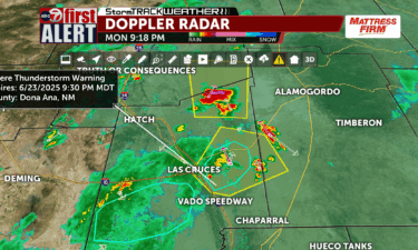
ABC-7 First Alert: Severe Thunderstorm Warning for Dona Ana and Otero Counties including Organ and White Sands Missile Range until 10:15 PM
The National Weather in El Paso has issued a Severe Thunderstorm Warning for East-Central Dona Ana County and Southwestern Otero County until 10:15 PM. This includes Organ and White Sands Missile Range. The main hazard in this storm is 60 mile per hour wind gusts and penny-sized hail. This storm is currently 14 miles south
Continue Reading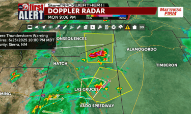
ABC-7 First Alert: Severe Thunderstorm Warning for Dona Ana and Sierra Counties until 10 PM
The National Weather Service in El Paso has issued a Severe Thunderstorm Warning for Northeastern Dona Ana County and East/Central Sierra County until 10 PM. This is mostly over rural area. The main hazards in this storm are radar indicated 60 mile per hour winds and quarter-sized hail. This storm is located 12 miles southwest
Continue Reading ABC-7 First Alert: Flash Flood Warning for Southwestern Dona Ana County until 10:30 PM
The National Weather Service in El Paso has issued a Flash Flood Warning for Southwestern Dona Ana County until 10:30 PM. Doppler radar indicates a complex of thunderstorms producing heavy rain across mostly rural area south of Interstate 10. Between 1 to 1.5 inches of rain may have fallen, additional rainfall up to 1 inch
Continue Reading